
Brunswick County 7-Day Weather Forecast: Thursday November 5, 2026
Unseasonably warm temperatures and mostly sunny skies will dominate Brunswick County through Thursday night before a cold front brings widespread rain, gusty winds, and a chance of severe afternoon thunderstorms heading into Friday.
Current Watches, Warnings & Marine Advisories
-
Thunderstorm & Rain Risk: High confidence of showers and thunderstorms on Friday (80% chance of precipitation), with heavy rain potential up to a quarter-inch (higher in thunderstorms) and wind gusts up to 16 mph.
-
Cooler Weekend Trend: A shifting wind pattern on Friday night will clear out moisture, bringing noticeably cooler and sunnier weather across the coastal region for the weekend and early next week.
Brunswick County Detailed Forecasts
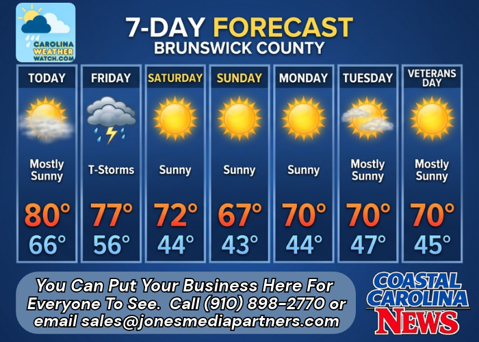
Brunswick County 7-Day Forecast
-
Today: Patchy fog before 9am. Otherwise, mostly sunny, with a high near 80. Calm wind becoming south 5 to 8 mph in the morning.
-
Tonight: Partly cloudy, with a low around 66. Light south wind.
-
Friday: A chance of showers and thunderstorms, then showers and possibly a thunderstorm after 3pm. High near 77. South wind 5 to 10 mph, with gusts as high as 16 mph. Chance of precipitation is 80%. New rainfall amounts between a tenth and quarter of an inch, except higher amounts possible in thunderstorms.
-
Friday Night: Showers and thunderstorms likely before 10pm, then a chance of showers between 10pm and 1am. Mostly cloudy, with a low around 56. Light and variable wind becoming north around 6 mph after midnight. Chance of precipitation is 60%. New precipitation amounts of less than a tenth of an inch, except higher amounts possible in thunderstorms.
-
Saturday: Sunny, with a high near 72.
-
Saturday Night: Mostly clear, with a low around 44.
-
Sunday: Sunny, with a high near 67.
-
Sunday Night: Mostly clear, with a low around 43.
-
Monday: Sunny, with a high near 70.
-
Monday Night: Mostly clear, with a low around 44.
-
Tuesday: Mostly sunny, with a high near 70.
-
Tuesday Night: Partly cloudy, with a low around 47.
-
Veterans Day: Mostly sunny, with a high near 70.
Safety Precautions & Preparedness Guidelines
Roadway Safety
-
Morning Fog & Low Visibility: Drive with low-beam headlights on Thursday morning during early commute hours due to patchy fog.
-
Hydroplaning Hazard: Rain and gusty winds on Friday afternoon and evening will reduce traction. Slow down on major thoroughfares including U.S. 17 and NC 211 during heavy downpours.
Ocean & Beach Safety
-
Rip Currents & Surf Conditions: Southerly winds gusting up to 16 mph ahead of Friday’s cold front will build ocean surf. Avoid swimming in unattended coastal water areas during peak storm activity.
© 2026 CoastalCarolinaNews.com | Jones Media Partners LLC
No content from this publication may be reproduced, republished, or used for commercial purposes without prior written authorization from Jones Media Partners LLC. For questions or comments call 910.898.2770 or you can reach out via our Contact Page.


Be the first to comment