
Horry County 7-Day Weather Forecast: Tuesday November 17, 2026
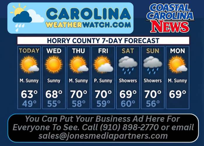
HORRY COUNTY, S.C. — Horry County residents can expect a stretch of mostly sunny skies and gradually warming temperatures through the end of the workweek before scattered shower chances return this weekend. Daytime highs will rise from the low 60s today into the upper 60s and near 70 degrees from Wednesday through early next week, accompanied by persistent northeast breezes.
Current Watches, Warnings & Marine Advisories
-
Active Watches/Warnings: No weather watches, warnings, or advisories are currently in effect for Horry County.
-
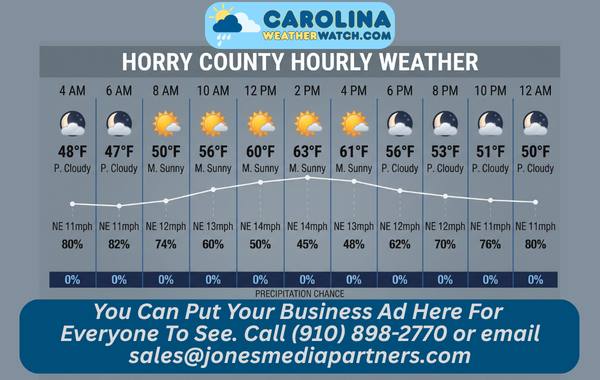
Wind & Weekend Outlook: Steady northeast winds of 11 to 15 mph—with daytime gusts reaching up to 21 mph on Wednesday and Thursday—will keep conditions breezy along the Grand Strand. Cloud cover will gradually build late Thursday into Friday ahead of a 30% to 40% chance of showers from Saturday through Sunday.
Horry County Detailed 7-Day Forecast
-
Today: Mostly sunny, with a high near 63°F. Northeast wind 11 to 14 mph.
-
Tonight: Partly cloudy, with a low around 49°F. Northeast wind 11 to 13 mph.
-
Wednesday: Sunny, with a high near 68°F. Northeast wind 13 to 15 mph, with gusts as high as 21 mph.
-
Wednesday Night: Mostly clear, with a low around 55°F. Northeast wind around 14 mph.
-
Thursday: Mostly sunny, with a high near 70°F. Northeast wind 13 to 15 mph, with gusts as high as 21 mph.
-
Thursday Night: Mostly cloudy, with a low around 58°F.
-
Friday: Partly sunny, with a high near 70°F.
-
Friday Night: Mostly cloudy, with a low around 59°F.
-
Saturday: A chance of showers. Partly sunny, with a high near 69°F. Chance of precipitation is 40%.
-
Saturday Night: A chance of showers. Mostly cloudy, with a low around 60°F. Chance of precipitation is 40%.
-
Sunday: A chance of showers. Mostly sunny, with a high near 70°F. Chance of precipitation is 30%.
-
Sunday Night: Partly cloudy, with a low around 56°F.
-
Monday: Mostly sunny, with a high near 69°F.
Safety Precautions & Preparedness Guidelines
Roadway Safety
-
Breezy Crosswinds & Sun Glare: High-profile vehicles crossing Intracoastal Waterway bridges and open stretches of Highway 17 and Highway 31 should watch for brisk northeast crosswinds gusting up to 21 mph Wednesday and Thursday. Bright sunshine and low November sun angles will also create strong glare during morning and late-afternoon commutes.
-
Weekend Wet Pavement: After several dry days, light oil buildup on roadways can make pavements slick when initial showers develop Saturday; allow extra following distance and reduce speed on wet roads.
Ocean & Beach Safety
-
Choppy Surf & Rip Current Risk: Persistent northeast winds of 11 to 15 mph with gusts to 21 mph will generate choppy surf and elevated rip current risks along Grand Strand beaches through Thursday. Boaters and anglers should check marine forecasts before heading offshore.
© 2026 CoastalCarolinaNews.com | Jones Media Partners LLC
No content from this publication may be reproduced, republished, or repurposed without prior written authorization from Jones Media Partners LLC.

Be the first to comment