

Horry County Forecast: Saturday November 21, 2026
Horry County – A High Surf Advisory is in effect along the Horry County coast as breezy east winds, afternoon and overnight showers with storm chances, and rough surf move in for the weekend. After lingering storm chances taper off Sunday, drier conditions return early next week before another round of rain arrives midweek ahead of Thanksgiving.
Current Watches, Warnings & Marine Advisories
-
High Surf Advisory: Issued by the National Weather Service in Wilmington, N.C., at 1:14 a.m. EST Saturday, Nov. 21, and in effect until 4:00 a.m. EST Sunday, Nov. 22. Large breaking waves of 4 to 6 feet are expected in the surf zone along Coastal Horry County (as well as Coastal Georgetown County), bringing dangerous swimming and surfing conditions and localized beach erosion.
Horry County Detailed 7-Day Forecast
-
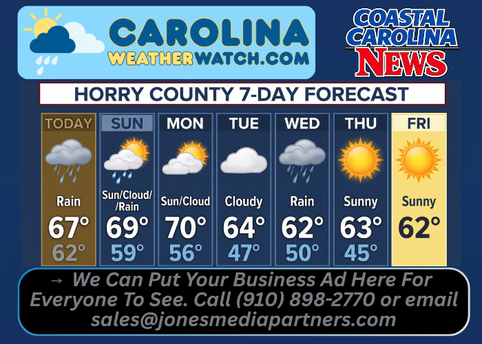
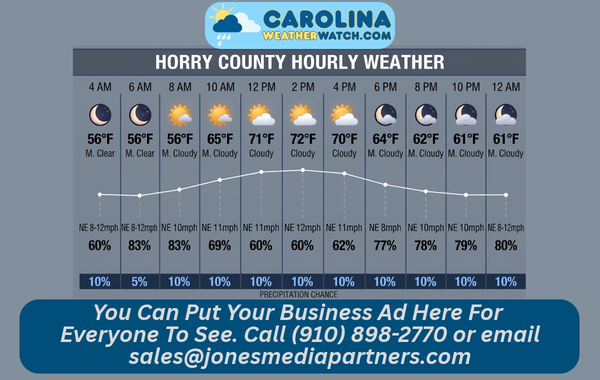
Today: Showers, mainly after 1:00 p.m. High near 67. Breezy, with an east wind 18 to 21 mph and gusts up to 33 mph. Chance of precipitation is 90%, with new rainfall amounts between a tenth and a quarter of an inch possible.
-
Tonight: Showers and possibly a thunderstorm, mainly before 3:00 a.m., then a chance of showers and thunderstorms after 3:00 a.m. Low around 62. Breezy, with an east wind 18 to 23 mph decreasing to 10 to 15 mph after midnight, and gusts up to 29 mph. Chance of precipitation is 100%, with new rainfall amounts between three-quarters and one inch possible.
-
Sunday: A chance of showers and thunderstorms, mainly between 1:00 p.m. and 2:00 p.m. Patchy fog before 8:00 a.m. Otherwise, partly sunny, with a high near 69. East wind 6 to 9 mph becoming west in the afternoon. Chance of precipitation is 40%, with new rainfall amounts under a tenth of an inch except higher amounts possible in thunderstorms.
-
Sunday Night: Partly cloudy, with a low around 59. Calm wind becoming west around 5 mph after midnight.
-
Monday: Partly sunny, with a high near 70.
-
Monday Night: Mostly cloudy, with a low around 56.
-
Tuesday: Mostly cloudy, with a high near 64.
-
Tuesday Night: A chance of showers after 1:00 a.m. Mostly cloudy, with a low around 47. Breezy. Chance of precipitation is 40%.
-
Wednesday: Showers likely. Mostly cloudy, with a high near 62. Breezy. Chance of precipitation is 70%.
-
Wednesday Night: A chance of showers. Mostly cloudy, with a low around 50. Windy. Chance of precipitation is 50%.
-
Thanksgiving Day: Mostly sunny, with a high near 63.
-
Thursday Night: Partly cloudy, with a low around 45.
-
Friday: Mostly sunny, with a high near 62.
Safety Precautions & Preparedness Guidelines
Roadway Safety
-
Slick Roads, Fog & Gusts: Watch for wet pavement, ponding, and gusty east winds up to 33 mph today and up to 29 mph tonight, plus patchy fog before 8:00 a.m. Sunday.
-
Nighttime & Storm Travel: Use extra caution during overnight rain and possible thunderstorms, and stay alert for changing visibility and crosswinds on bridges and open stretches.
Ocean & Beach Safety
-
High Surf & Swimmer Protocols: With 4- to 6-foot breaking waves and dangerous swimming and surfing conditions in effect until 4:00 a.m. Sunday, inexperienced swimmers should stay out of the water.
-
Beach Erosion & Rip Currents: Avoid standing near steep shoreline drop-offs or localized erosion spots, and use extreme caution around piers, jetties, and rip-current zones.
© 2026 CoastalCarolinaNews.com | Jones Media Partners LLC
No content from this publication may be reproduced, republished, or used for commercial purposes without prior written authorization from Jones Media Partners LLC.

Be the first to comment