
Brunswick County 7-Day Weather Forecast: Tuesday November 3, 2026
Brunswick County will enjoy unseasonably warm afternoon temperatures through the middle of the week, with highs reaching near 80 degrees under sunny to mostly sunny skies. Light easterly winds will shift southerly by Thursday before an approaching front brings a 40% chance of showers and isolated afternoon thunderstorms on Friday, followed by a slight cool-down heading into early next week.
Current Watches, Warnings & Marine Advisories
-
Coastal & Tidal Waterway Monitoring: Minor tidal inundation and elevated water levels remain possible along low-lying shorelines, marshlands, and tidal tributaries during peak high tide cycles.
-
Boating & Marine Safety: Light to moderate easterly winds with gusts up to 16 mph today will generate mild chop across inland sounds and waterways. Exercise caution on open waters.
Brunswick County Detailed Forecasts
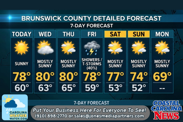
Brunswick County 7-Day Detailed Forecast
-
Today (Tuesday): Sunny, with a high near 78. East wind 5 to 9 mph, with gusts as high as 16 mph.
-
Tonight: Mostly clear, with a low around 60. Northeast wind around 5 mph.
-
Wednesday: Mostly sunny, with a high near 80. East wind 5 to 8 mph.
-
Wednesday Night: Partly cloudy, with a low around 63. East wind around 5 mph becoming calm in the evening.
-
Thursday: Mostly sunny, with a high near 80. Calm wind becoming south 5 to 7 mph in the morning.
-
Thursday Night: Mostly cloudy, with a low around 65.
-
Friday: A 40% chance of showers, with thunderstorms also possible after 1:00 PM. Partly sunny, with a high near 78.
-
Friday Night: A 30% chance of showers. Mostly cloudy, with a low around 59.
-
Saturday: Mostly sunny, with a high near 77.
-
Saturday Night: Partly cloudy, with a low around 53.
-
Sunday: Mostly sunny, with a high near 74.
-
Sunday Night: Partly cloudy, with a low around 52.
-
Monday: Mostly sunny, with a high near 69.
Safety Precautions & Preparedness Guidelines
Roadway Safety
-
Thunderstorm & Rain Hazards: Rain chances peak on Friday afternoon with potential localized thunderstorms. Be prepared for slick roadways, sudden downpours, and reduced visibility. Allow extra stopping distance during commute hours.
-
Tidal Waterway Inundation: Shallow water pooling remains possible during high tide cycles on coastal causeways and low-lying secondary roads near tidal creeks. Never drive through flooded stretches of road.
Ocean & Beach Safety
-
Rip Currents & Surf: Onshore easterly winds will maintain longshore currents and localized rip current risks along east- and south-facing beaches. Swim only near designated lifeguard stations.
-
Beach Erosion & High Tides: Elevated high tides could push water close to dune bases on narrow beach stretches along Oak Island, Holden Beach, Ocean Isle Beach, and Sunset Beach. Avoid walking beneath unstable sand banks.
© 2026 CoastalCarolinaNews.com | Jones Media Partners LLC
No content from this publication may be reproduced, republished, or used for commercial purposes without prior written authorization from Jones Media Partners LLC. For questions or comments call 910.898.2770 or you can reach out via our Contact Page.


Be the first to comment