

Columbus County 7-Day Weather Forecast: Tuesday November 3, 2026
Columbus County will experience very warm, pleasant daytime conditions through the middle of the week, with temperatures climbing into the lower 80s under sunny to mostly sunny skies. Quiet overnight conditions will bring patchy early-morning fog before a strong cold front introduces a 70% chance of showers and thunderstorms on Friday, followed by a noticeable cooling trend heading into early next week.
Current Watches, Warnings & Marine Advisories
-
Hazardous Weather Outlook: No active warnings or advisories are currently in place for Columbus County. Residents should monitor Friday’s forecast as thunderstorms are possible.
County Detailed Forecasts
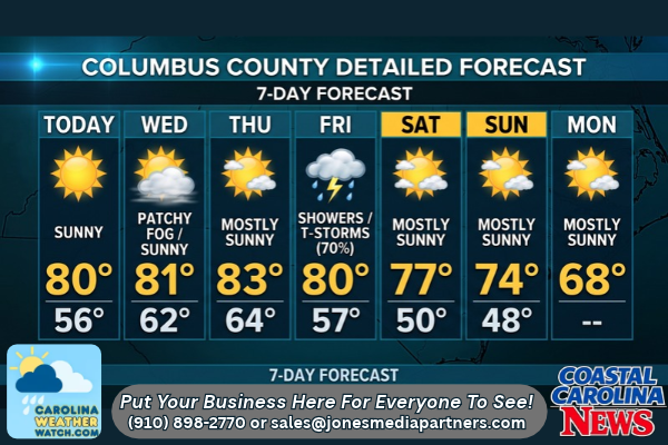
Columbus County Detailed Forecast
-
Today (Tuesday): Sunny, with a high near 80. Calm wind becoming east around 6 mph in the morning.
-
Tonight: Mostly clear, with a low around 56. Calm wind.
-
Wednesday: Patchy fog before 8:00 AM. Otherwise, mostly sunny, with a high near 81. Calm wind becoming southeast around 5 mph in the afternoon.
-
Wednesday Night: Partly cloudy, with a low around 62. Light southeast wind.
-
Thursday: Mostly sunny, with a high near 83. Calm wind becoming south around 6 mph in the afternoon.
-
Thursday Night: Mostly cloudy, with a low around 64.
-
Friday: Showers likely, with thunderstorms also possible after 1:00 PM. Mostly cloudy, with a high near 80. Chance of precipitation is 70%.
-
Friday Night: A chance of showers before 1:00 AM. Mostly cloudy, with a low around 57. Chance of precipitation is 40%.
-
Saturday: Mostly sunny, with a high near 77.
-
Saturday Night: Partly cloudy, with a low around 50.
-
Sunday: Mostly sunny, with a high near 74.
-
Sunday Night: Partly cloudy, with a low around 48.
-
Monday: Mostly sunny, with a high near 68.
Safety Precautions & Preparedness Guidelines
Roadway Safety
-
Morning Visibility: Watch for patchy, dense morning fog early Wednesday, particularly before 8:00 AM in low-lying and rural areas. Drive with low-beam headlights and allow extra travel time.
-
Friday Wet Weather: Wet roadways and possible ponding will create hazardous driving conditions on Friday when rain and thunderstorm chances peak at 70%. Reduce speeds and anticipate slick intersections.
Outdoor & Storm Prep
-
Mid-week Yard Work: Take advantage of dry, warm weather through Thursday for outdoor tasks before wet and stormy weather arrives on Friday.
-
Storm Vigilance: Monitor local radar on Friday afternoon for any potential strong wind gusts or frequent lightning associated with afternoon storms.
© 2026 CoastalCarolinaNews.com | Jones Media Partners LLC
No content from this publication may be reproduced, republished, or used for commercial purposes without prior written authorization from Jones Media Partners LLC. For questions or comments call 910.898.2770 or you can reach out via our Contact Page.


Be the first to comment