

Horry County 7-Day Weather Forecast: Tuesday November 3, 2026
Breezy onshore winds will keep conditions active along the Horry County coast today, starting off a warm and mostly dry week before a cold front brings a 50 percent chance of rain and thunderstorms on Friday.
Expect sunny skies today with a high near 73, though easterly winds will gust up to 20 mph. Patchy fog may briefly impact the Wednesday morning commute, but will give way to a mostly sunny afternoon with a high of 75. Temperatures peak on Thursday at 76 degrees before moisture surges ahead of Friday’s front, introducing afternoon thunderstorm possibilities. A clearing trend Friday night will set up a comfortable, slightly cooler weekend, with highs in the low 70s on Saturday and Sunday.
Current Watches, Warnings & Marine Advisories
-
Beach & Surf Monitoring: Onshore east to northeast winds will sustain moderate to high rip current risks along east- and south-facing beaches. Stronger gusts up to 20 mph today will keep surf conditions choppy. Swimmers should exercise caution and obey local beach flags.
County Detailed Forecasts
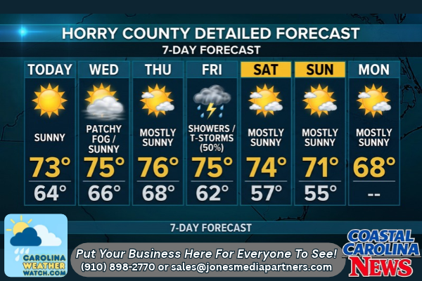
Horry County Detailed Forecast
-
Today (Tuesday): Sunny, with a high near 73. East wind 10 to 14 mph, with gusts as high as 20 mph.
-
Tonight: Mostly clear, with a low around 64. Northeast wind 8 to 11 mph, with gusts as high as 17 mph.
-
Wednesday: Patchy fog before 8:00 AM. Otherwise, mostly sunny, with a high near 75. East wind 7 to 9 mph.
-
Wednesday Night: Partly cloudy, with a low around 66. East wind 3 to 6 mph.
-
Thursday: Mostly sunny, with a high near 76. Southeast wind 3 to 7 mph.
-
Thursday Night: Partly cloudy, with a low around 68.
-
Friday: A 50% chance of showers, with thunderstorms also possible after 1:00 PM. Partly sunny, with a high near 75.
-
Friday Night: A 30% chance of showers before 1:00 AM. Mostly cloudy, with a low around 62.
-
Saturday: Mostly sunny, with a high near 74.
-
Saturday Night: Partly cloudy, with a low around 57.
-
Sunday: Mostly sunny, with a high near 71.
-
Sunday Night: Partly cloudy, with a low around 55.
-
Monday: Mostly sunny, with a high near 68.
Safety Precautions & Preparedness Guidelines
Roadway Safety
-
Wednesday Morning Fog: Patchy fog is expected early Wednesday morning, particularly before 8:00 AM. Motorists should use low-beam headlights, reduce speeds, and allow extra stopping distance, especially on inland routes and highway bridges.
-
Breezy Travel: Gusty winds today up to 20 mph may affect high-profile vehicles on open roads and bridges. Keep both hands on the wheel.
-
Wet Roadways Friday: Friday’s 50% chance of rain and storms may lead to localized ponding and slick road conditions. Reduce speeds during your Friday commutes.
Ocean & Beach Safety
-
Rip Currents: Choppy surf and strong winds will maintain a persistent rip current risk. Do not swim alone, and avoid getting into the water if red flags are flying.
Here is your completed update for Horry County. I hope this covers everything you need for the news desk today!
© 2026 CoastalCarolinaNews.com | Jones Media Partners LLC
No content from this publication may be reproduced, republished, or used for commercial purposes without prior written authorization from Jones Media Partners LLC. For questions or comments call 910.898.2770 or you can reach out via our Contact Page.

Be the first to comment