
Columbus County 7-Day Weather Forecast: Friday November 6, 2026
A potent cold front pushing across Columbus County will bring 100% certainty of rain, localized heavy downpours, and potential thunderstorm activity on Friday afternoon before clearing out for a sunny, cool weekend.
Current Watches, Warnings & Marine Advisories
-
Thunderstorm & Heavy Rain Risk: 100% chance of precipitation on Friday, with showers and thunderstorms capable of bringing between a quarter and half an inch of rain (higher amounts possible in thunderstorms).
-
Winds & Clearing Trend: Rain lingers into Friday evening (60% chance), then clears out overnight as light winds shift northerly around 5 mph, bringing weekend highs into the upper 60s and lows down to around 40°F.
Columbus County Detailed Forecasts
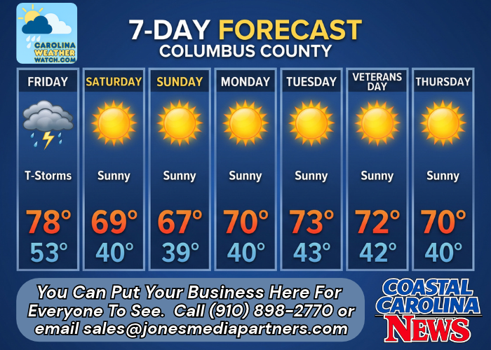
Columbus County 7-Day Detailed Forecast
-
Overnight: Increasing clouds, with a low around 66. Calm wind.
-
Friday: A chance of showers and thunderstorms, then showers and possibly a thunderstorm after 1pm. High near 78. Calm wind becoming south 5 to 7 mph. Chance of precipitation is 100%. New rainfall amounts between a quarter and half of an inch possible.
-
Friday Night: Showers likely, mainly before 7pm. Mostly cloudy during the early evening, then gradual clearing, with a low around 53. Calm wind becoming north around 5 mph after midnight. Chance of precipitation is 60%. New precipitation amounts between a tenth and quarter of an inch possible.
-
Saturday: Sunny, with a high near 69. North wind 5 to 8 mph, with gusts as high as 15 mph.
-
Saturday Night: Mostly clear, with a low around 40. Light north wind.
-
Sunday: Sunny, with a high near 67.
-
Sunday Night: Mostly clear, with a low around 39.
-
Monday: Sunny, with a high near 70.
-
Monday Night: Clear, with a low around 40.
-
Tuesday: Sunny, with a high near 73.
-
Tuesday Night: Mostly clear, with a low around 43.
-
Veterans Day: Sunny, with a high near 72.
-
Wednesday Night: Mostly clear, with a low around 42.
-
Thursday: Sunny, with a high near 70.
Safety Precautions & Preparedness Guidelines
Roadway Safety
-
Flooding & Slick Conditions: Expect reduced visibility and ponding of water on roads like U.S. 74 and U.S. 701 on Friday afternoon and evening. Use caution and allow extra travel time.
-
Gusty Winds: Keep a firm grip on the steering wheel on Saturday as northerly winds gust up to 15 mph.
Coastal & Drainage Safety
-
Agricultural & Low-Lying Runoff: Heavy downpours could cause temporary localized ponding in low-lying agricultural zones and roadside ditches through Friday night.
© 2026 CoastalCarolinaNews.com | Jones Media Partners LLC
No content from this publication may be reproduced, republished, or repurposed without prior written authorization from Jones Media Partners LLC.


Be the first to comment