
Columbus County 7-Day Weather Forecast: Thursday November 19, 2026
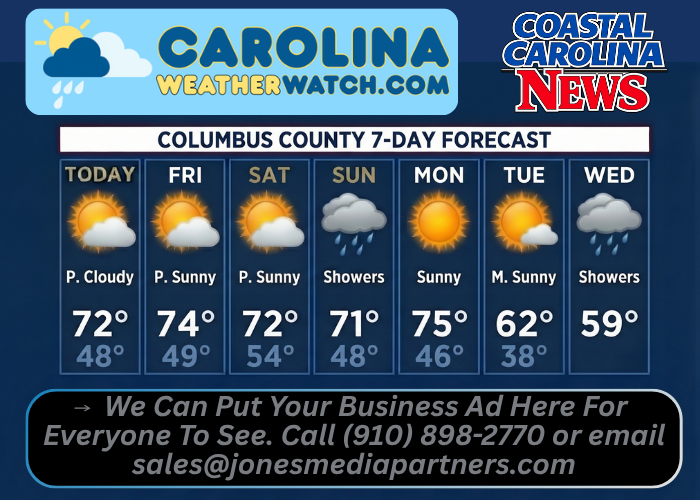
COLUMBUS COUNTY, N.C. — Columbus County residents can expect mild daytime temperatures in the low-to-mid 70s through Monday alongside increasing cloud cover and light northeast winds before scattered shower chances arrive late Saturday night into Sunday. Following a sunny Monday high near 75 degrees, cooler air settles in by Tuesday and Wednesday with daytime highs dipping into the upper 50s and low 60s.
Current Watches, Warnings & Marine Advisories
-
Active Watches/Warnings: No weather watches, warnings, or advisories are currently in effect for Columbus County.
-
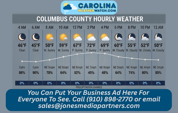
Wind & Rain Outlook: Light northeast winds of 3 to 8 mph will accompany increasing clouds today through Friday night. A 40% chance of showers arrives after 1:00 a.m. Saturday night and continues through Sunday before another 30% to 40% chance of showers returns Tuesday night into Wednesday.
Columbus County Detailed 7-Day Forecast
-
Today: Increasing clouds, with a high near 72°F. Calm wind becoming northeast 5 to 7 mph in the morning.
-
Tonight: Mostly cloudy, with a low around 48°F. Light northeast wind.
-
Friday: Partly sunny, with a high near 74°F. Northeast wind 5 to 8 mph.
-
Friday Night: Mostly cloudy, with a low around 49°F. Northeast wind 3 to 6 mph.
-
Saturday: Partly sunny, with a high near 72°F.
-
Saturday Night: A chance of showers after 1:00 a.m. Mostly cloudy, with a low around 54°F. Chance of precipitation is 40%.
-
Sunday: A chance of showers. Partly sunny, with a high near 71°F. Chance of precipitation is 40%.
-
Sunday Night: Partly cloudy, with a low around 48°F.
-
Monday: Sunny, with a high near 75°F.
-
Monday Night: Partly cloudy, with a low around 46°F.
-
Tuesday: Mostly sunny, with a high near 62°F.
-
Tuesday Night: A chance of showers. Mostly cloudy, with a low around 38°F. Chance of precipitation is 30%.
-
Wednesday: A chance of showers. Partly sunny, with a high near 59°F. Chance of precipitation is 40%.
Safety Precautions & Preparedness Guidelines
Roadway Safety
-
Late-Saturday Into Sunday Wet Pavement: After several dry days, light oil accumulation on roadways can make pavements slick when scattered showers arrive after 1:00 a.m. Saturday night and linger into Sunday; reduce speed and allow extra stopping distance along U.S. 74/76 and rural county roads.
-
Morning Sun Glare: Early sunshine prior to increasing clouds today and on Monday morning combined with low November sun angles can create strong glare during early commutes; keep windshields clean and sunglasses accessible.
Lake & Outdoor Safety
-
Lake Waccamaw & Chilly Tuesday Night Low: Light northeast winds and mild temperatures offer favorable conditions on Lake Waccamaw through Saturday afternoon, though boaters should monitor radar Saturday night into Sunday. Overnight temperatures dipping to around 38°F Tuesday night may also bring patchy frost in low-lying rural pockets.
© 2026 CoastalCarolinaNews.com | Jones Media Partners LLC


Be the first to comment