
Warm, Seasonable Weather Holds Through Friday Before Weekend Rain Arrives Across Coastal Carolinas
Residents across Horry County can look forward to mild, sunny conditions through Friday before a cold front brings precipitation and a noticeable autumn cooldown for the weekend.
Current Watches, Warnings & Marine Advisories
-
Marine Gusts & Offshore Seas: Small craft operators should exercise caution Friday afternoon through Saturday night, as southwest winds will gust up to 17 mph ahead of the incoming cold front.
-
Rip Currents: Always exercise caution in the surf zone. Monitor local beach flags and swim near a lifeguard when available.
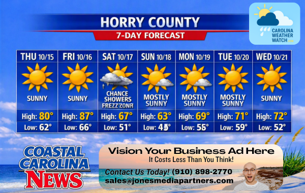 Horry County Detailed Forecast
-
Today: Sunny, with a high near 81. South wind 5 to 8 mph.
-
Tonight: Mostly clear, with a low around 68. South wind 6 to 8 mph.
-
Friday: Sunny, with a high near 80. South wind 6 to 13 mph, with gusts as high as 18 mph.
-
Friday Night: Increasing clouds, with a low around 66. Southwest wind 13 to 15 mph, with gusts as high as 21 mph.
-
Saturday: A chance of showers. Partly sunny, with a high near 67. Breezy, with a north wind around 21 mph, with gusts as high as 29 mph. Chance of precipitation is 40%. New precipitation amounts of less than a tenth of an inch possible.
-
Saturday Night: A slight chance of showers before 2 a.m. Partly cloudy, with a low around 51. Breezy. Chance of precipitation is 20%.
-
Sunday: Mostly sunny, with a high near 63. Breezy.
-
Sunday Night: Partly cloudy, with a low around 55. Breezy.
-
Monday: Mostly sunny, with a high near 69. Breezy.
-
Monday Night: Partly cloudy, with a low around 58.
-
Tuesday: Mostly sunny, with a high near 71.
-
Tuesday Night: Mostly clear, with a low around 59.
-
Wednesday: Sunny, with a high near 71.
Safety Precautions & Preparedness Guidelines
Roadway Safety
-
Wet Roads: Wet leaf debris and light rain on Saturday can make roadways slick during initial rainfall. Allow extra stopping distance on coastal highways and rural routes.
-
Nighttime Driving: Temperatures drop rapidly Saturday night into the upper 40s; ensure vehicle tire pressures are properly set for seasonal cooling.
Ocean & Beach Safety
-
Rip Currents: Stronger south-southwest winds Friday afternoon into Saturday will create choppy surf conditions along south- and east-facing beaches.
-
Boating Conditions: Boaters should monitor wind gusts up to 17 mph and rising seas ahead of Saturday’s cold front. Always check local marine forecasts before heading offshore.
© 2026 CoastalCarolinaNews.com | Jones Media Partners LLC
No content from this publication may be reproduced, republished, or used for commercial purposes without prior written authorization from Jones Media Partners LLC. For questions or comments call 910.898.2770 or you can reach out via our Contact Page.

Be the first to comment