
Horry County 7-Day Weather Forecast: Sunday November 1, 2026
Horry County is in for a breezy and unseasonably warm week, with daytime temperatures hovering in the 70s and overnight lows mostly in the 60s. Highs will reach the mid-70s starting Tuesday. Consistent northeast winds will bring gusty conditions early in the week before moisture increases, ushering in a 30% chance of showers after midnight on Wednesday and a 40% chance of rain on Thursday. Skies will clear up by Friday, offering a mostly sunny start to the weekend.
Current Watches, Warnings & Marine Advisories
-
Wind & Marine Alerts: Sustained northeast winds of 11 to 17 mph—with gusts reaching as high as 24 mph today and tomorrow—will create hazardous conditions for small craft and choppy surf along the coast. Expect elevated rip current risks at local beaches. Use extreme caution on the water.
-
Tidal Inundation: Minor tidal flooding is possible during high tide cycles in low-lying coastal areas and near the Intracoastal Waterway.
Horry County Detailed Forecasts
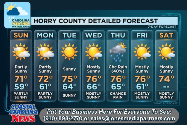
Horry County 7-Day Detailed Forecast
-
Today: Partly sunny, with a high near 71. Northeast wind 14 to 17 mph, with gusts as high as 24 mph.
-
Tonight: Mostly cloudy, with a low around 59. Northeast wind 13 to 16 mph, with gusts as high as 23 mph.
-
Monday: Partly sunny, with a high near 72. Northeast wind 13 to 15 mph, with gusts as high as 22 mph.
-
Monday Night: Partly cloudy, with a low around 61. Northeast wind 11 to 14 mph, with gusts as high as 21 mph.
-
Tuesday: Sunny, with a high near 75. East wind 11 to 15 mph, with gusts as high as 21 mph.
-
Tuesday Night: Partly cloudy, with a low around 64.
-
Wednesday: Mostly sunny, with a high near 76.
-
Wednesday Night: A 30% chance of rain after 1:00 AM. Mostly cloudy, with a low around 66.
-
Thursday: A 40% chance of rain. Partly sunny, with a high near 76.
-
Thursday Night: Partly cloudy, with a low around 65.
-
Friday: Mostly sunny, with a high near 76.
-
Friday Night: Mostly clear, with a low around 61.
-
Saturday: Mostly sunny, with a high near 74.
Safety Precautions & Preparedness Guidelines
Roadway Safety
-
Gusty Winds: High-profile vehicles should exercise extra caution on bridges and overpasses, especially along the US-17 bypass and the Intracoastal Waterway bridges, due to gusts up to 24 mph through Monday night.
-
Wet Roadways: With a 40% chance of rain on Thursday, motorists should prepare for potentially slick roads. Reduce speed and allow extra braking distance.
Ocean & Beach Safety
-
Rip Current Risk: Rough surf and strong currents are expected due to persistent, gusty onshore winds. Swimmers are advised to stay out of the ocean unless lifeguards are present, and never swim alone.
-
Beachfront Winds: Secure loose outdoor items on beachfront properties, balconies, and patios as gusts will remain high into the middle of the week.
© 2026 CoastalCarolinaNews.com | Jones Media Partners LLC
No content from this publication may be reproduced, republished, or used for commercial purposes without prior written authorization from Jones Media Partners LLC. For questions or comments call 910.898.2770 or you can reach out via our Contact Page.

Be the first to comment