
Horry County 7-Day Weather Forecast: Monday November 2, 2026
Horry County is set for a breezy and unseasonably warm week, with daytime temperatures hovering in the 70s and overnight lows primarily in the 60s. Consistent northeast to east winds will bring gusty conditions early in the week before moisture increases, ushering in a 40% chance of showers on Friday.
The week begins with partly sunny skies today and a high of 71, accompanied by gusty northeast winds up to 22 mph. Sunshine returns in full on Tuesday as temperatures climb to 75 degrees, with east winds continuing to gust up to 20 mph. The warm trend peaks on Thursday at 77 degrees under partly sunny skies before scattered showers become possible on Friday (40% chance). Clearer, cooler conditions arrive just in time for the weekend, with sunny skies on Saturday and a comfortable high of 73.
Current Watches, Warnings & Marine Advisories
-
Elevated Surf & Winds: Gusty northeast-to-east winds ranging from 9 to 16 mph (with gusts up to 22 mph) will create choppy surf and a high risk of rip currents along area beaches through midweek.
-
Boating Alert: Small craft should exercise caution due to persistent onshore gusts and rough seas.
Horry County Detailed Forecasts
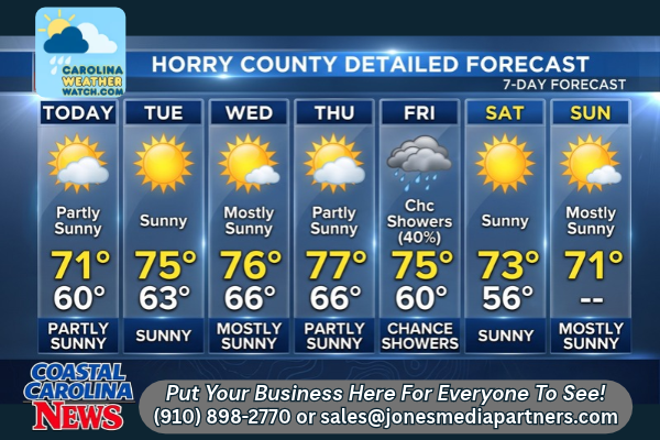
Horry County 7-Day Detailed Forecast
-
Today (Monday): Partly sunny, with a high near 71. Northeast wind 13 to 16 mph, with gusts as high as 22 mph.
-
Tonight: Mostly clear, with a low around 60. Northeast wind 9 to 13 mph, with gusts as high as 18 mph.
-
Tuesday: Sunny, with a high near 75. East wind 9 to 14 mph, with gusts as high as 20 mph.
-
Tuesday Night: Partly cloudy, with a low around 63. East wind 9 to 11 mph, with gusts as high as 17 mph.
-
Wednesday: Mostly sunny, with a high near 76. East wind 8 to 10 mph, with gusts as high as 15 mph.
-
Wednesday Night: Mostly cloudy, with a low around 66.
-
Thursday: Partly sunny, with a high near 77.
-
Thursday Night: Partly cloudy, with a low around 66.
-
Friday: A 40% chance of showers. Partly sunny, with a high near 75.
-
Friday Night: Partly cloudy, with a low around 60.
-
Saturday: Sunny, with a high near 73.
-
Saturday Night: Partly cloudy, with a low around 56.
-
Sunday: Mostly sunny, with a high near 71.
Safety Precautions & Preparedness Guidelines
Roadway Safety
-
High-Profile Vehicle Caution: Drivers of high-profile vehicles should stay alert on bridges, overpasses, and open highways—including Highway 17 and the waterway bridges—due to wind gusts up to 22 mph.
-
Wet Roadways Friday: Friday’s 40% chance of rain may make roads slick, especially after several dry days. Allow extra distance between vehicles.
Ocean & Beach Safety
-
Rip Currents: Strong onshore winds will continue to generate rough surf. Avoid swimming in unmonitored areas, and heed any local beach flags.
-
Loose Items: Secure lightweight outdoor furniture or beach gear, as persistent gusts over 15-20 mph will continue through Tuesday.
© 2026 CoastalCarolinaNews.com | Jones Media Partners LLC
No content from this publication may be reproduced, republished, or used for commercial purposes without prior written authorization from Jones Media Partners LLC. For questions or comments call 910.898.2770 or you can reach out via our Contact Page.

Be the first to comment