

Strong Cold Front Delivers Rain, Gusty Winds, and Chilly Temperatures to Horry County
HORRY COUNTY, SC — A potent autumn cold front sweeping across the Grand Strand and inland Horry County will bring showers, powerful northerly winds, and a steep temperature drop today.
Showers are expected primarily between 11 AM and 5 PM as temperatures fall into the upper 50s by late afternoon. Wind speeds will intensify significantly tonight, with sustained northerly winds near 26 mph and gusts reaching up to 37 mph along the coast. While sunny skies return for Sunday, windy and breezy conditions will linger through early next week alongside crisp, cooler air.
Current Watches, Warnings & Marine Advisories
-
Wind Advisory & Gusty Winds: Strong northerly winds will blow 13 to 23 mph today with gusts up to 34 mph, increasing tonight to 24–26 mph with gusts as high as 37 mph. Gusty conditions will persist through Sunday and Monday with gusts ranging from 29 to 33 mph.
-
Marine & Coastal Hazards: Hazardous marine conditions, high surf, and elevated rip current risks are expected along Grand Strand beaches due to sustained, powerful northerly winds through early next week.
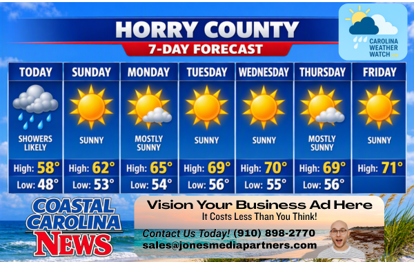
Horry County Detailed Forecast
-
Today: Showers likely, mainly between 11 AM and 5 PM. Mostly cloudy, with a temperature falling to around 58°F by 5 PM. Breezy, with a north wind 13 to 23 mph, with gusts as high as 34 mph. Chance of precipitation is 60%. New precipitation amounts of less than a tenth of an inch possible.
-
Tonight: Mostly cloudy during the early evening, then gradual clearing, with a low around 48°F. Windy, with a north wind 24 to 26 mph, with gusts as high as 37 mph.
-
Sunday: Sunny, with a high near 62°F. Breezy, with a north wind around 23 mph, with gusts as high as 31 mph.
-
Sunday Night: Mostly clear, with a low around 53°F. Breezy, with a north wind around 23 mph, with gusts as high as 33 mph.
-
Monday: Mostly sunny, with a high near 65°F. Breezy, with a north wind 20 to 22 mph, with gusts as high as 29 mph.
-
Monday Night: Partly cloudy, with a low around 54°F.
-
Tuesday: Sunny, with a high near 69°F.
-
Tuesday Night: Mostly clear, with a low around 56°F.
-
Wednesday: Sunny, with a high near 70°F.
-
Wednesday Night: Partly cloudy, with a low around 55°F.
-
Thursday: Mostly sunny, with a high near 69°F.
-
Thursday Night: Partly cloudy, with a low around 56°F.
-
Friday: Sunny, with a high near 71°F.
Safety Precautions & Preparedness Guidelines
Roadway Safety
-
Bridge & Highway Driving: Motorists traveling along SC-31, US-17, and elevated waterways/bridges across the Intracoastal Waterway should exercise extreme caution. High-profile vehicles, campers, and towed trailers will face strong crosswinds gusting over 35 mph tonight and Sunday.
-
Slick Roads: Light afternoon showers combined with road oils can create slick driving conditions during peak midday hours. Maintain safe following distances.
Coastal & Property Safety
-
Beach & Marine Precautions: Swimmers and surfers should stay out of the ocean due to rough surf, strong longshore currents, and heightened rip current risks brought on by persistent 30+ mph gusts.
-
Secure Property: Secure lightweight outdoor furniture, porch displays, trash cans, and outdoor Halloween decorations ahead of tonight’s high wind gusts.
© 2026 CoastalCarolinaNews.com | Jones Media Partners LLC
No content from this publication may be reproduced, republished, or used for commercial purposes without prior written authorization from Jones Media Partners LLC. For questions or comments call 910.898.2770 or you can reach out via our Contact Page.

Be the first to comment